
The Morning Glory cloud
Episode #9 of the course “Rare and Unusual Weather Phenomena”
A Morning Glory cloud is a phenomenon that occurs under the right atmospheric conditions, where an atmospheric wave creates long bands of rolled clouds (or “arcus” clouds). The exact cause of the specific cloud formations has not yet been fully explained, but it is speculated that air front movements and humidity combine to create these wonders.
Although these clouds can occur around the world, the Gulf of Carpentaria in Northern Australia is the only place where the phenomenon can be predicted, as it has the right type of atmospheric conditions on a regular basis. From September to November every year, observers in the town of Burketown gather to witness the Morning Glory cloud spread over the gulf.
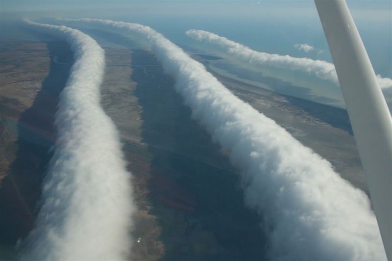
Morning Glory clouds are very close to the ground—often as low as 350 feet (106 meters)—and extend up to a little over a mile in the air. However, they are very long, often stretching for 500 or 600 miles (800-1000 kilometers). The clouds move a few feet each second in a process of forming new cloud at the front and dissipating at the tail end. They maintain their structure better over water than dry land and often leave thunderstorms trailing behind them.
The Australian town of Burketown has become a popular tourist attraction for the Morning Glory clouds. Because of the clouds’ predictability and the increased excitement of viewing them from the air, pilots of gliders from around the world have begun to gather during the most frequent months of Morning Glory clouds in order to “surf” or glide along the rows of rolled up sky. The town has begun to host an annual festival for gliders looking for these adventures.
Share with friends